If you're new here, you may want to subscribe to my RSS feed. Thanks for visiting!
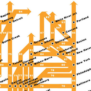
Chris Yates has created a map of the Eisenhower Interstate System, simplified as a subway-style infographic. If you’re traveling to one of the top few dozen largest cities in the US, it’s all you’ll ever need.
Link
0 Responses to “US interstate system, done tube-style”
An escapee from a government contractor’s test lab, the monkey lives in hiding, hacking away at the keyboard to bring you random thoughts, stories, news, and graphics. Depending on his mood, he may be informative, amusing, obnoxious, or inane.


0 Responses to “US interstate system, done tube-style”